The sun shone brightly as we enjoyed breakfast at our modest two star hotel in Agilcevaz. Mehmet got up early (of course) and met an elderly Dutch lady at breakfast. She was surprised to meet English speakers and we were surprised to meet any non-Turk. This lady was amazing - she has traveled in Turkey pretty extensively it seems and was a doing a long and comprehensive sweep of eastern Turkey. She had come from the Agri Dagi (Mount Ararat) area and gave us some advice on where to stay, etc. She planned to visit Ahlat (our first destination of the day) before moving on to Mardin. We invited to her to join our excursion to Ahlat but she said she needed that day as a rest day as the journey from Dogubeyazit the previous day by bus and dolmus (small ad hoc van service) was taxing. What a special woman to tackle a venture like this at her age! Happy travels!
We drove the half hour or so back to Ahlat and parked at the town museum. This free place was small but interesting and we enjoyed the collection. Just behind the museum is the huge Selcuk cemetery. During Selcuk times, Ahlat was a big and important city (it is now a small town) and this cemetery is the largest one of its kind in Turkey (and, by extension, the world). It stretches for acres over a field with nice views to the lake and the mountains. The gravestones varied from tall and well carved to more modest ones. There were a few underground and building tombs. Off to the distance a few of the famous kumbets could be seen. However, to view these kumbets we chose to drive to them.
 |
| Mehmet enters the museum at Ahlat while one of the custodians cleans the entry on this early morning |
 |
| The entry to this free museum |
 |
| One of the pieces in the Ahlat museum |
 |
| One of the outside treasures of the museum |
 |
| Some of the impressive tombstones of the Selcuk cemetery |
 |
| A close up of one of the larger tombstones |
 |
| The "cross of David" is also a traditional Selcuk symbol and has nothing to do with Judaism here |
 |
| Some impressive carving |
 |
| Mehmet and Randy are impressed with the number and quality of the Selcuk graves |
 |
| Both men and women are buried here |
 |
| A few tombs are underground |
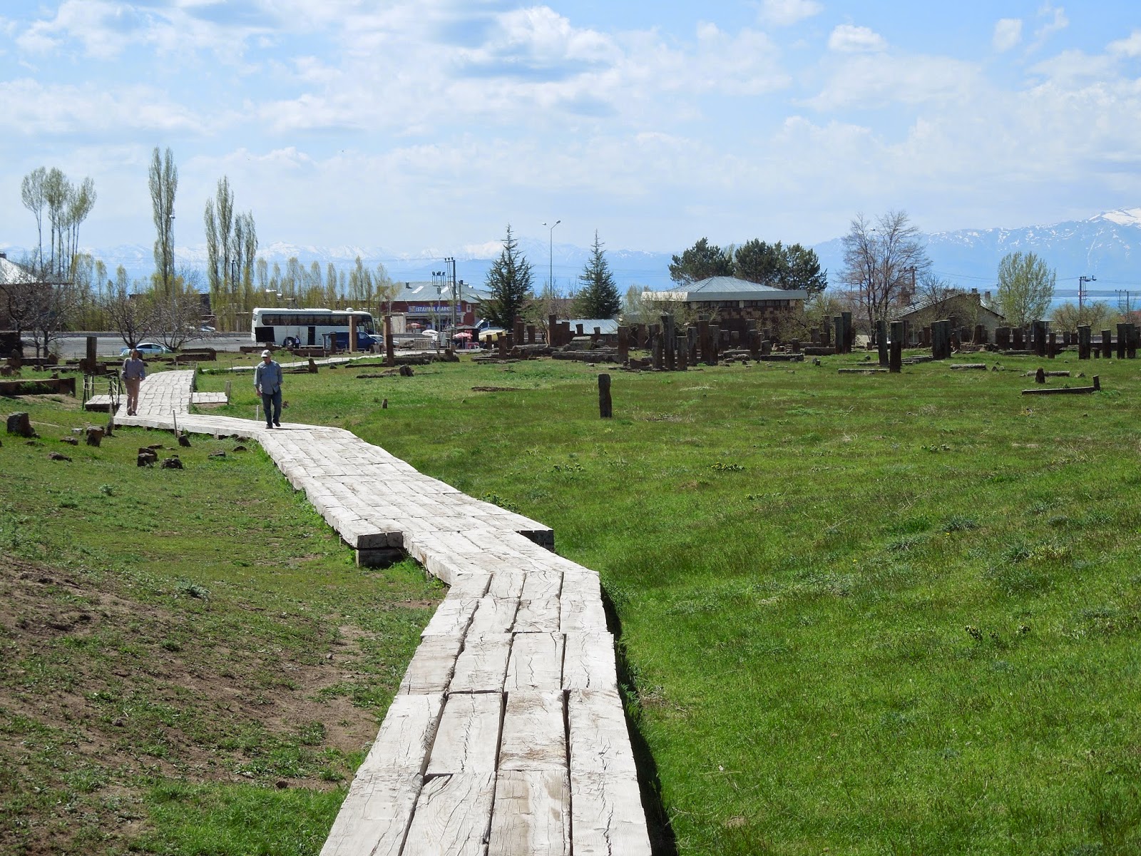 |
| The cemetery is well kept and set up for visitors, of which there are few. Even the museum is moving to larger and newer quarters soon. |
 |
| The views over to the mountains are wonderful - both majestic and peaceful |
 |
| The day was perfect for sightseeing |
A kumbet is a Selcuk mausoleum based on the Selcuk's original homes of tents - literally a tent for eternity. They are made of stone and are cylindrical (or octagonal) with the deceased buried in the base portion and the part above left vacant. They mainly date from the 12th century. Kumbets can be seen in other places in Turkey (Kayseri, for example). But, Ahlat is the treasure trove of kumbets.
We did walk to the largest kumbet in Ahlat, which is a few blocks towards the lake from the museum. Local children took up with us and were fascinated with the aspect of meeting Americans. We also communed with local sheep and goats in the yard of the kumbet (it doubles as a convenient grazing ground). The kids kind of ruined the experience by asking for money at the end (which we did not give) but we can forgive them for this impoliteness.
 |
| The largest kumbet in Ahlat, a few blocks walk from the museum |
 |
| The locals were letting their sheep and goats graze in the kumbet yard while we were there |
 |
| Taken from the second floor - Randy and the local kids |
 |
| The carving on this one was impressive |
 |
| Some of the kids. Like other places in Turkey the coloring of the people varies. You find blonds, redheads and blue eyes among the normally darker populace. |
 |
| The herd tries to get out of the small entry all at once |
 |
| The kids were thrilled with the friendliness of Mehmet and the chance to meet two Americans |
 |
| The kumbet. The tomb is in the bottom part and the top part (reached by the steps) contains nothing. |
Driving around Ahlat we viewed several other kumbets including one in someone's front yard. We also ventured to the old city with its picturesque bridge and rock tombs. Our way out of the town was a road literally lined with kumbets. It was almost overwhelming. Ahlat deserves to be on every itinerary of eastern Turkey - it has remarkable history that is well preserved in a setting that is difficult to improve upon. However, we saw almost no other visitors despite this being a Saturday in May with good weather. There was a small French group at the cemetery when we left but they did not appear to go anywhere else. We had the kumbets to ourselves.
 |
| This kumbet stands next to a working mosque. and is famed for its open colonnade. Mehmet met the Iman inside and got an overview of the mosque, its history and current operations. |
 . . |
| The Iman takes Mehmet (and Alice) around the small but historic mosque |
 |
| Carving detail of the kumbet |
 |
| Another detail |
 |
| A final view of this splendid twosome |
 | ||
The unusual and well done columns
|

 |
| The kumbet in the yard |
 | ||
| It was only partially completed or the top part was destroyed |
 |
| A view of the old city from the next kumbet site - on a plateau with views also to the lake (see below) |
 |
| View of the old Selcuk bridge from the high area of the kumbet below |
 |
| This kumbet dates from the heyday of kumbet - the 1200's |
 |
| The location was great with lake views although the road to it was hard to find |
 | ||
| Panoramic from the kumbet area |
 |
| Rock tombs and houses in the old town of Ahlat |
 |
| The old bridge at Ahlat. When we were there there were also a group of men, presumably on the religious outing. |
 |
| Mehmet does love his fountains! If there is a fountain along a back road or, in this case, by the bridge, he wants to sample the water and wash from it. Randy and Alice are a little more hesitant about the water quality. But, none of his has ever made Mehmet the least bit sick. |
 |
| One of the kumbets along the main kumbet road through Ahlat. |
 |
| Here it is with an interesting ground floor opening |
 |
| The twin kumbets shared great views of the mountains and lake |
 |
| Here are the twins |
Thence we set off along the northern shore of Lake Van towards Dogubeyazit, the nearest town to Mount Ararat (Agri Dagi) and the nearest town to our next main quest - the palace fortress of Isak Pasa. The drive was pretty spectacular with views to the mountains (passing massive Mount Suphan) and to the lake. We broke the journey with a stop at park built around a natural waterfalls. This is Muradiye and the falls are several kilometers north of the town itself but just off of the main road. It was full of Turkish picnickers on this Saturday. But we enjoyed the falls and the swinging bridge. We ate very nice local trout at the restaurant just over the swinging bridge. We also make a bathroom break. (Not so easy to do on this trip - these had to be planned strategically due to the lack of facilities in the regions. They always involved the traditional Turkish toilet - a hole in the floor.)
 |
| Mount Suphan from the road on the north side of the lake. We are heading east. |
 |
| The swinging bridge at the waterfalls park at Muradiye |
 |
| Mehmet and Randy enjoyed the falls area |
 |
| Alice and Randy - you can see it was a bit chilly that day |
 |
| All possible twosomes - here are Mehmet and Alice |
 |
| You can eat yummy fish (and other foods) at this restaurant just over the swinging bridge |
 |
| The local trout was fried in butter and pretty delicious. Note the head in the foreground. |
 |
| Randy enjoys the bountiful lunch which was a good thing because we ended up not getting dinner until quite late |
Climbing higher northeast of Lake Van we came very close to the border with Iran. We could easily the Turkish fortifications. We were told that on the Iran side (also all Kurdish here) there were no fortifications. The Turks are mainly worried about the Kurdish extremists using bases in Iran to carry out nefarious activities on the Turkish side, thus the intense fortifications. We reached Dogubeyazit in later afternoon. After gassing up and checking out the hotel options (all dismal), we headed the short drive to Isak Pasa Sarayi (Palace).
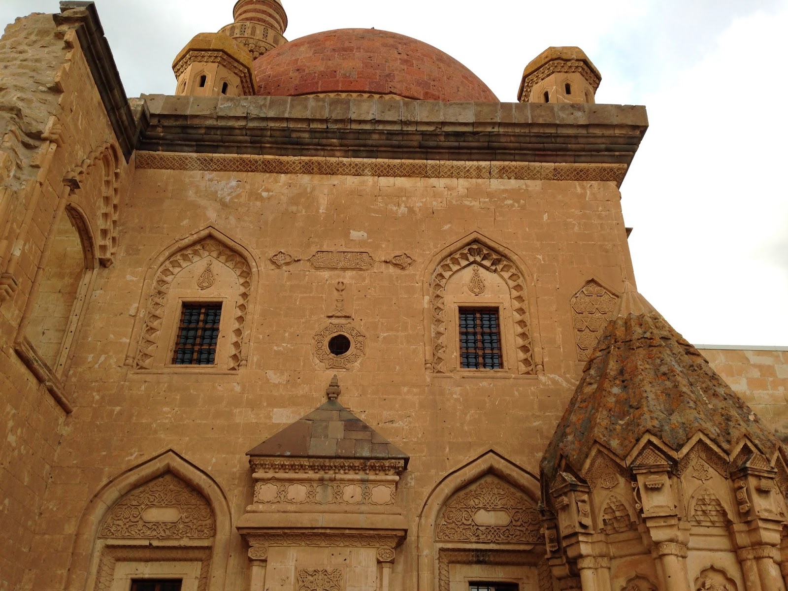
This fortification has a commanding site overlooking the valley and backed by mountains. It was built in the late 1600's so is not old by Turkish standards. The palace was known for its amenities which were unusual at the time such as running water, central heating, and indoor toilets. It was used over the years by many groups as a fortification, one the final times by the Russians in the early part of the 20th century. It has been restored (actually over-restored) and a good road leads up to it. It was fairly crowded with Turkish tourists on this Saturday of a holiday weekend. It is impressive with some aspects well worth traveling for (the mosque, the central room in the harem, the view) but parts of the fortress seemed quite ordinary and restored with way too much zeal.
 |
| One of the many Turkish guard posts along the Iranian border |
 |
| One of the blown volcanoes on the road to Dogubeyazit - notice the lava flows (which are extensive) in the foreground |
 |
| Just outside of Dogubeyazit - cow dung is dried and stacked to use as full in this area with almost no trees nor bushes |
 |
| Isak Pasa looms above, the effect sadly impaired by the modern lights and electric lines |
 |
| Across from Isak Pasa is a mosque, fortifications and tomb (this last is out of sight off to the right) |
 |
| The entrance sign to this well known and well visited attraction |
 |
| The threesome at the entrance to the palace |
 |
| View from the palace up to the old fortifications. It is possible to climb there though we did not have time to do so. |
 |
| Some intricate carvings |
 |
| The dungeons were suitably spooky and foreboding |
 |
| A high window in one of the dungeon chambers. Food was dropped from above through a slot at the bottom of the window. |
 |
| Another dungeon chamber |
 |
| The last dungeon chamber had no door - the unlucky prisoners were lowered by rope from this entry in the celing |
 |
| Mehmet and Randy did not relish the idea of spending much time in the dungeon |
 |
| More carving ornamentation |
 |
| Windows in the outer courtyard |
 |
| Interesting window area |
 |
| Reuse of an older carved piece in one of the courtyard walls |
 |
| View from the Isak Pasa Sarayi |
 |
| Splendid painted dome of the mosque |
 |
| Carved column details. You can see the modern superstructure at top right (in red) which put a plexiglass roof over the parts of a palace which lacked a roof. |
 |
| Another view of the mosque and fortress area across from the palace. The rock formations in the area are varied and beautiful. |
 |
| Carved entry detail. These are reminiscent of those found in Selcuk hans. |
 |
| A distant rainstorm is visible from the palace. The modern city of Dogubeyazit can be seen on the plain on the left said of the photo. |
 |
| Carved wooden decoration on one outer wall viewed from an interior window |
 |
| A description of this room and shows the wooden carvings are combined human, lion and eagle - what a trio! |
 |
| An interior |
 |
| The wonderful carved tomb (pictured below) stands in the courtyard adjacent to the mosque |
 |
| The impressive tomb |
 |
| Another view |
 |
| A double selfie by the tomb |
 |
| The tomb (lower right) with mosque behind - the dome is visible at top |
 |
| A nicely carved lion detail |
 |
| One room of the palace was used for the storage of bits and pieces and lit in a spooky way |
 |
| The harem houses the single most impressive space in the palace |
 |
| The fabulous interior of the harem |
 | ||||
Around the walls are these small poems / sayings which celebrate the superiority of the lord of the palace and wishing him long life and happiness. Reminders to the harem ladies about who is boss.
|


 |
| A carved detail in the interior |
 |
| One of the interior rooms with a handsome fireplace |
 |
| The kitchen area is covered with soot from the Russian and Turkish soldiers who camped out there more than 100 years ago |
 |
| View towards Dogubeyazit from the third (and last) courtyard of the palace |
 |
| One of the stone toilets. This may not seem like much but compare it to the alternatives of the day. |
 |
| The view to the interesting colored hills near Isak Pasa Sarayi |
 |
| A bit of carved graffiti more than 100 years old |
 |
| Alice and Mehmet by the tomb and mosque |
 |
| Another view across the hills from the palace parking lot - we would shortly take the back road up into these high hills |
We drove to a nearby tomb and mosque dedicated to the Kurdish poet and philosopher Ahmed Xani of the late 1600's which Mehmet viewed (while Randy waited in the car and Alice took outside pictures). Then, the sense of adventure overtook us. What happened next was unexpected but a highlight of the entire trip. Mehmet was keen to see the Iranian border, about 45 minutes or so away. His detailed map and GPS showed a back road through the mountains and we were already in the the lower part of the mountains we decided to follow this road. The road went through remote villages (we stopped at each one to inquire on the road state ahead and make sure we were going in the right direction - at one, an old and probably crazy lady insisted we give her money) and high pasture lands - the true yayla. Yayla is a Turkish term for summer grazing grounds. Now it is used to often mean a summer house in the mountains but here the term is apt in its original meaning - these are quite elevated locations where the herds graze during the months of warmer weather.
 | |||
The tomb and mosque across from the Isak Pasa Sarayi
 |

 |
| A view of the palace from the tomb / mosque seen above in the afternoon light. Too bad the streetlight detracts from the view. Otherwise, the photo could have been taken a few hundred years ago. |
The road was gravel. (The Avis lady from whom rented at the airport in Van told us to stay off of gravel roads. Not only did we disobey her, we also drove on dirt roads, across a stream and even briefly across country. The Ford Focus kept going through it all though it probably badly needs a wheel alignment now.) It was tricky as the grades were steep and rails were non-existent. We would have all perished if the car went over the edge. This became a real possibility when, towards the highest part of the road, it started sleeting, snowing and hailing all together. After some anxious minutes, we reached lower ground where the precipitation was only light rain.
 |
| The grazing area of the high yayla just east of Isak Pasa Sarayi |
 |
| Some of the late afternoon beauty of this untraveled corner of Turkey |
 |
| One of the remote villages in the high yayla |
 | |||
| Naturally, we were held up by flocks returning to the villages before dusk. The man at the right was carrying a long rifle (we asked directions from him after the herd had passed). The village people graze the flocks together during the day and then sort them out when they return to the village in the early evening. You can see the extent of our cracked windshield with this photo. |
 |
| View of the greater Agri Dagi from this high back road |
We pressed on but soon encountered a small stream which was cut through the road. For a tractor or four wheel drive vehicle, this would not have proven difficult. For a Ford Focus, it was a challenge of the first order. We put some flat large rocks in the stream where the wheels could go over then Mehmet and Alice guided Randy (sometimes with conflicting yells) over the stream. Success!
 |
| The Ford Focus made it over the stream crossing with the help of stones we placed in strategic locations and the guidance of Mehmet (at right of the car). If we had gotten stuck, someone with a tractor from one of the villages would have had to pull us out. The rental car lady would be furious with us for taking her vehicle in places it was not designed to go. |
As we passed the last village before joining the main road, we were surprised to see a brown sign (this means a cultural or historic site in Turkey) and a couple of mini-vans of French (or were they Italian?) tourists. We had stumbled on the small museum dedicated to Noah's Ark (which supposedly landed in the Mount Ararat region). The museum had a few items of interest and a gregarious (to Mehmet) ancient caretaker. He pointed out a geologic formation some distance off (not on Mount Ararat) that was supposedly the outline of Noah's Ark. It was both unbelievable and interesting at the same time. Randy was thrilled as he had especially wanted to see Mount Ararat and Noah's Ark during this trip to eastern Turkey.
 |
| This is Noah's Ark in Turkish |
 |
| Inside the small museum some supposed finds from the arc were on display |
 |
| The caretaker (on right) showed us around. There were many interesting articles on the "proofs" found over the years of the presence of Noah's Ark in this area. |
 |
| The outline of the presumed petrified Noah's Ark. You can make out a boat shaped formation in the center of the photo with the raised area forming the middle of the ark. |
 |
| The museum caretaker and Mehmet. Mehmet tipped him well and we all decided he had quite a racket going with the visitors to this one room museum. No admission charge but certainly tips are expected. |
We reached the main road (so ordinary after our travels of the past two hours) and headed east to Iran. There were countless big trucks stopped at the frontier (probably for the night as things were not moving). We parked and walked as far as we could. Mehmet thought that Randy and I could leave Turkey and get as far as the Iranian side before being turned back (we had no Iranian visa). Mehmet, himself, did not bring his Turkish nor American passports. We declined this opportunity and stayed clearly on the Turkish side of the border. We met a Pakistani who had been deported from Iran for an unspecified (unspecified by him, that is) crime and did not know what to do next. There a few pedestrians walking from Turkey to Iran, probably Iranians who did some Turkish shopping. We soaked up the faintly dangerous and definitely dreary atmosphere then made the 45 drive to downtown Dogubeyazit.
 |
| Near the Iranian border. Many trucks were lined up and apparently the border was closed to truck traffic for the night. |
 |
| Mehmet was fascinated by this border area but we could only view it from the Turkish side |
If there is a worst town in Turkey, it would have to sink far to beat Dogubeyazit for this dubious distinction. Modernization and improvement have passed Dogubeyazit by. The roads, even in the city central, were horrendous. The city was dirty and lacked amenities. As far as we could tell, there were no decent hotels and no decent restaurants. We stayed where the Dutch lady recommended, the Hotel Grand Derya. This had the advantages of being right downtown, having a parking lot and good internet. Otherwise, it was pretty comfortless and extremely run down and basic. We were told (the next day) that they had better rooms but on the other side of the hotel. We particularly asked to be put on the side away from the neighboring mosque as the call to prayer came at about 4:30 AM. Taking the hardship rooms in the interest of more sleep was for naught - the muezzin missed the early morning call to prayer that Sunday morning!
 |
| The three star Hotel Grand Derya in Dogubeyazit. It is, at best, a two star and hardly deserves "Grand" in the title. |
 |
| Randy and Alice's room included a space heater (not needed) and a small TV (not turned on) |
We ate nearby at a restaurant attached to an upstairs movie theater. This was basically Turkish fast food but surprising tasty and with a wide menu. We were dying for a beer but there is no restaurant in Dogubeyazit that serves alcohol. Mehmet and Alice made due with a scotch miniature each back in the hotel room. The lesson learned here is to not stay in Dogubeyazit but drive on to to the small city of Igdir, one of our destinations of the following day.
 |
| Another view of the tomb and mosque area of Isak Pasa Sarayi in the late afternoon light |
 |
| Three compatible travelers - we share the same sense of adventure and wide interest in all things of history and nature. We also have complementary roles for our expeditions. And, we all like good (but not fancy) food and drink! |
No comments:
Post a Comment